|
|
|
Today we were heading North and crossing over the imaginary line of Southern Maine to Mid-coast Maine. It’s mid August now and the weather forecast is for 10-20 knots winds, 2-4 foot seas coming from the S or SW with 1-3 mile visibility. Chance of scattered thunder showers are expected for this afternoon. This is the first time cruising these waters and it will be interesting to see how the weather report reflects the actual conditions. When we cruised Alaska, the reports covered such a wide area that you really were on your own trying to figure out what the weather would be in your particular cruising area. We’ll see how it is here. The coast of Maine has been divided in three sections by the books we’ve been reading. They are each described as being very different from each other in physical, historical and social aspects. Mid-coast Maine is said to stretch from just north of Portland (where we are) to the “western shores of Penobscot Bay”. This includes the wonderful island of Monhegan, and the Boothbay region, Pemaquick, Rockland, Camden and Belfast. They say there are no more sandy beaches as the coastline rapidly becomes ragged and rocky, filled with islands and long finger peninsulas. The European history here is fascinating and we are constantly reminded that it goes back well beyond the first arrivals of the Pilgrims who first set foot on the shores of Massachusetts. The fearless fishermen who set up early fishing camps are the real early settlers according to the Mainers. They established camps in the remotest of places along the coast of Maine, places such as island of Monhegan and Damariscove Island, to mention a few that we will pass by as we head north. LEAVING THE DOCK Larry encouraged me to take Knotty Dog out of the marina today. I didn’t feel very confident as the opening out I had to go through heading out into the harbor between two docked boats was very narrow and I wasn’t sure I had the experience to judge the space. I visibly wasn’t sure if the width of the boat would clear it though I knew it did because Larry brought her in here. I would have to make a critical turn part way through the narrow area to miss another boat just ahead and wasn’t sure if I understood the timing to do it without scraping the back part of the boat on another boat behind. We didn’t have any turning room either where we were docked to get her into position before I headed towards the opening. Larry convinced me I could do it but I made him stand by me all the way. I took her gently off the
dock with the bow thrusters and began a small turn with the bow. We have
a swim step in the back of the boat that we added when we bought the boat.
It adds 3 extra feet to the length and is sometimes deceptive and throws you
off. You think you have enough room to clear but then have to remember
there’s that extra three feet. Larry said to give the stern thruster
more thrust, so obviously I was a little tight to the dock. I pushed the
throttle on the stern thruster and then put her lightly into forward gear
thinking the slower and more careful I went, the better I will be able to
maneuver. Larry came up and said give her more speed, so I guess it
needed more speed or power to give her more control.
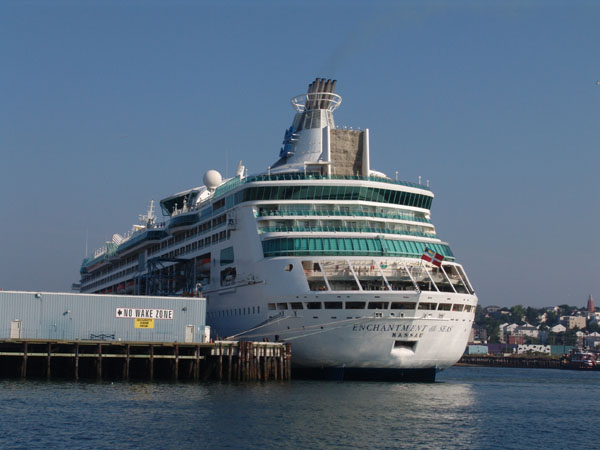
The morning sun was in our face and suddenly after the tense few moments of wondering if I (we) could get her out of that dock space, now we’re in the main shipping channel of Portland. I remember from our Trolley Tour yesterday that Portland Harbor is the Northern most ice free port on the East Coast. Canada depends on it as it brings all their oil in through this port. The oil is taken off the ships and is piped across Maine to the Canadian border. To my left was a huge cruise ship that must have come in last night. Now, that explains the large swells we felt at the dock last night. Several lobster boats were heading out to sea and I just followed in behind. Larry brought the fenders in and then took the wheel as I tied and stowed the lines off the rails ready for our next port. We’re now passing the old fort on our portside today and admire the beautiful homes on our starboard that lead out past Portland Lighthouse that we visited by trolley the day before. I can see why the trolley guide said it was the most photographed light house. It is truly a pleasant sight.
HEADING OUT TO CASCO BAY Guests have left and we’re on our own again. They came in a burst and now we’re suddenly by ourselves. Now I can think. We love to have guests but it thoroughly throws me off my regular routine. I really don’t pay attention to the surroundings when guests are aboard as we’re laughing and talking. I’m also thinking about what and where we are going, trying to make sure they will like where we take them are enjoying themselves. Sometimes it’s very difficult to know where to take friends that come to visit because we don’t know the ports and anchorages. Every place is new and unpredictable but we have had such great people for guests that always go with the flow. That’s what makes them special, as they can enjoy their environment no matter where they are. MISTAKE OF READING TOO MUCH Today we are just free to sit back and not carry on a conversation or worry about what we’re eating next, so that in itself is relaxing. I made one mistake though before we left and that the mistake of reading too much. I just started The Edge of Maine, by Geoffrey Wolff, and love it but I realize now, he’s definitely made an impression on me. I’ve became so engulfed in all his woes of cruising and getting lost among the fog and going aground on rocks and all his stories of people getting in trouble cruising in these waters that I’ve definitely got an edgy stomach going out this morning.
EDGY from THE EDGE OF MAINE Larry’s tracking our course out past the lighthouse taking us towards Witch Rock. I glance over at the electronic charts and can’t read clearly how deep it is. Our course looks like we are going to cross over an area that shows only 2 feet below us. I check the paper charts which are easier to read and it says 23’. I guess I’m a bit edgy from reading The Edge of Maine and all its mention of people getting stuck on hidden ledges. He described cruising in Maine…. “Holding a precise course across the Gulf of Maine was no petty imperative. The currents swirl erratically and given poor visibility an on-the-button landfall would be a matter of blind hazard.” “It’s (Maine’s) chief topographical attraction—rock-strewn coasts and myriad islands----makes close to shore sailing a grim option. Sailing Down East once upon a time separated lambs from wolves.” Given the fact that we aren’t sailing, we’re power boating, and the other fact that we have state of the art electronics on board, still didn’t soften the “edge” I was feeling today after reading his book the night before. 90% of the time, I’m much better off, not reading a thing about cruising waters until I’m about a hundreds miles from the spot I’m reading about. Reading these descriptions of woe and danger do something to my imagination, all sensibility goes to the wind. FOG His descriptions of sailing in the fog too, gave me a fearful apprehension of any weather predictions with fog now, even though we’ve cruised in pea soup, monitoring radar screens with no problem. He would describe woeful currents dragging boaters precariously close to rocky submerged shallow ledges. He would quote other cruising books, warning that to sail in the fog (in Maine) is a misguided adventure and “you might as well have your head in a bag”. Why were these waters all of a sudden different from other areas we’ve cruised? He describes currents swirling, and pulling you left and right, “fog factories of the Bay of Fundy and the Labrador Current, more common than sunshine.” Now if I heard that there was any inkling of forecast of fog I was worried. Reading about a broadcast put out through the Canadian Broadcasting Corporation didn’t help either, saying that “Fog Kills Songbirds in Bay of Fundy!” “Fishermen tell of sea birds falling onto their decks from the sky; the birds---lost in the fog---become wet and heavy, too cold and miserable to fly.” I had heard warnings of married couples cruising in Maine who get socked in to remote anchorages for weeks with fog. It was so tough on the marriage relationship that some never survive and end of selling the boat and getting divorced. Some say that “fog can keep you anchored so long in one place that you’d ground on your own beer cans before you’d dare move.” Geoffrey Wolff quotes another misadventure, “Roger Duncan has described sailing in a Penobscot Bay fog so thick that the Vinalhaven ferry coming in from Rockland with radar couldn’t find her slip.” “Even the birds be walkin” it’s so thick. I hope we don’t have this to look forward too as we head north. Fortunately today, no fog was predicted.
We’re going the same route now that we did when we left Kennebunkport to Jewell Island but the seas are not the same. The four foot waves are rolling in series towards us. We see the cluster of islands at the southern tip of Jewell Island. The first group of islands is called Junk of Pork. I have no idea why they called them Junk of Pork but it gave us a chuckle. We passed Jewell Island where we anchored on the protected NW side over a week ago. It was a beautiful little anchorage and I regret that we didn’t explore the island more by hiking to the old army lookout but at the time the bugs were out in full force. We passed Half Way Light. I’m reading that all the lighthouses were built after ship wrecks and deaths. Mmm nice. This one was built in 1871 and had a light keeper who would row the 11 miles from Portland and back for supplies. To me that seems an impossible task. Larry says that he thinks Half Way Light marks the half way distance to something but we couldn’t figure out what. It was lonely out here, nothing out here except for a few scattered lobster pots. We saw three huge yachts, one going north (or Down East as they say) but looking like he’s headed straight out to sea, another going south, and one crossing in behind us, probably heading toward South Freeport. I’m not really enjoying looking out the window today as the swells are huge. They are as tall as the pilot house and are starting to have white caps. The sea feels so different up here. The temperature off the water is cold and the swells and waves feel strong against the boat. They look very determined. The rocky ledges of the islands are beautiful but a warning to keep alert. We pass Eagle Island on our left, too far to photograph, but I can make out Admiral Peary’s house on this remote isolated Island. Anyone who would choose to live on such a remote island with such difficult seas and weather surely is of the stuff to discover the North Pole. We pass the markers identifying Drunkers Ledge and Eastern Drunkers Ledge and we can only imagine how they got their names. We are off shore quite a ways now taking a more direct route to Boothbay. It’s a feeling of comfort to be away from the rocky shores and hidden ledges but we have no rest even out here as we are still constantly dialing the auto pilot to avoid the lobster pots. The huge swells just outside the pilot house are still slowly but steadily rolling towards us. Off to our portside is Ragged Island where the author of another book I’m reading got stuck in bad fog. It looks so harmless today but as I look in the binoculars, it’s lonely with only a desolate looking wooden structure. Next to Ragged Island is White Bull Island which is the whitest island around, not a tree, grass or bush, just white rock. Then just beyond is Mark Island where every square foot is covered with trees and shrubs. Go figure why one is bare and another covered in foliage and then still another completely different just covered in brown earth and called Brown Cow. It’s like White Bull Island, treeless, grassless, and shrub less but instead of being white, it’s of course brown and rocky.
What the heck? Yes, that’s what they say. The name Sequin Island translates to “where the sea vomits”. We are experiencing unruly seas today but no vomiting. If this is any description of what the seas are like around this high mounded island on a bad day, I don’t want to get near it. The Sequin Island Light is perched on top of the high crested island on a grassy knoll. It looks pleasant and picturesque. The light is clear and flashing and has been a welcoming sight to many a weary mariner. Today the shores though have no calm place, nor what we could see as a safe landing for the light keeper of days past. There are a few buildings scattered on the north side of the island where boaters can pick up a mooring or two when the weather is settled. There is a large ramp from that point that heads up the steep hill to the lighthouse. A MADMAN RESIDED HERE Sequin Island is beautiful from the distance as the lighthouse is perched on top of this green mound of an island. It’s hard to imagine looking at the beauty of it, that a story is told, as there are of many lighthouses, of ghosts and strange tales and this place has one that could top them all. During the 19th century one of the lighthouse keeper’s wives had a piano. It is said that she played the same tune over and over again until she finally drove him mad and he chopped the piano into pieces with an ax, killed his wife and finally himself. Of course some say on still nights they swear they can still hear her playing the song over and over. As we pass the island we must go by the Sequin Ledges. They are barely exposed rocky ledges. They are covered with birds and seals sunning themselves. We have been warned in the cruising guides that there is a magnetic disturbance at Ellingwood Rock near the ledges but we can’t pick up any change. Once past the Sequin Ledges the winds suddenly die down to 6 knots from 15+ knots. The seas have calmed too. The tide is changing and starting to run in our favor for our last leg of the journey today to Boothbay. The seas have calmed down.
KENNEBEC RIVER Sequin Island Light also marks the outer reaches of the entrance to Kennebec River and Popham Beach. At the Kennebec River entrance is another lighthouse marking the river’s entrance. Popham is famous in the history books as the place where early colonists made an earnest attempt to form a first colony here in 1606, but “failed miserably” though they did manage to make the first sailing vessel in New England called the Virginia to cruise and explore the surrounding areas. History also left its mark on these shores some years later when a fort was built to protect the upper reaches of the Kennebec River during the Civil War. We could see its fortress like walls in the distance as we cruised by. The Kennebec River of course is very famous for the many great ship builders that settled along this river. Its deep waters were perfect for launching deep draft ships and the abundant nearby pine forests, made perfect ship masts. So it made for a natural place to design and build ships. Many famous ships have sailed to sea from this river. Even today the area is world renown for building and launching our country’s naval destroyers and other commercial vessels up the river at Bath Iron Works. As we cross over the entrance to this famous river, on the northern shores we see many lovely cottages that line the rocky precipices of the shoreline. They are surrounded by beautiful thick forests. We head across Sheepscot Bay and weave our way past numerous rocky shoals. To our starboard are the rocks called Sisters. On our left are The Black Rocks. In between paying attention to all these scattered rocks, ledges, and the lobster pots, we see ahead the start of the dreaded fog. The temperatures are cooling and the air is damp and the land, rocks, and surrounding boats are turning that whitish gray in the haze. Everything is staring to blend together into one monotone shade of grey white. We still have good viability but why did I read those darn cruising books. Each author seems to revel in telling you misfortunate experiences, the dangers of cruising this area, or the notorious bad squall. Sometimes don't you wonder if they aren’t exaggerating just a little the danger of their situation?
It’s our first whale sighting off The Black Rocks in Sheepscot Bay! Not a big one or a very dramatic exiting. We only saw just the very tip of the dorsal fin and back and a large blow. He or she is a small one, but nevertheless, our first whale sighting on this trip!
DAMARISCOVE ISLAND We cross Sheepscot Bay and make our way around Cuckolds point. Off to our right is Damariscove Island which was an established fishing camp long before the Pilgrims arrived in Plymouth. Not much is written in the general history books but every history book of Maine will remind you. Fishermen from the continent of Europe fished these plentiful waters in the summer and dried their catch on the shores of Damariscove Island long before any lands were settled here. “It’s not surprising that we read little of this in published accounts, for most of these men were illiterate; and furthermore, no fisherman, having discovered a good place to fish, is eager to advertise it to others.” Even the Pilgrims knew of it and in their year of distress, 1621, they sent Edward Winslow to Damariscove for help. Of the island, Charles K. Bolton writes in The Real Founders of New England: “It is not too much to affirm that Damariscove was, from 1608, let us say, to 1625, the chief maritime port of New England. Here was the rendezvous for English, French and Dutch ships crossing the Atlantic, and for trade between Damariscove and New Netherland as well as Virginia to the south. Here men bartered with one another and with Indians, drank, gambled, quarreled, and sold indentured servants.” Wow, imagine that all before the pilgrims arrived! Now it is an uninhabited island protected by the Nature Conservancy who occupy and protect the island in the summer months. Lucky dogs!
Well, we missed the big fog bank, leaving it out there somewhere off the shores of Damariscove Island. It turned out to be a beautiful stretch of water heading up Booth Bay and into Booth Bay Harbor. Beautiful islands surround us sprinkled with quaint summer cottages. We again encounter the biggest lobster mine field yet. We can see it in the distance and right in the center of it is the sailing school with their little boats weaving back and forth through them like it was nothing. We carefully head into the field of pots doing our best not to cut any lobster lines but it is no easy task as they are everywhere and closely packed. As we get more inside the harbor, it is crowded not only with lobster pots but moored boats. The harbor is beautiful though with marina after marina and as many lobster pounds. We hail our dock master on the radio as we near our destination and are told there’s a boat still in our slip. They think the captain and crew are having lunch somewhere and can we hang out in the harbor for a bit while they try to find them? Hanging out in the harbor for a bit is no easy task as there really isn’t a lot of room between the moored boats, the lobster pots and the many excursion boats going in and out. We said fine and did our best. It was after their check out time so why was the boat still there? A bit inconsiderate with think. The current is running a good clip in the harbor which doesn’t make things easier as we’re trying our best to stay in one small open spot that we found. We’re constantly checking around us for lobster pots to stay away from them. Finally after a half hour of this we call the dock master again and ask how it’s going. They apologize profusely and say they found the captain and the boat should be leaving shortly. We are watching the dock through our binoculars trying to see what’s going on. We think we see the boat they are trying to get to leave. It’s a huge, probably 90 foot blue hulled yacht and no one seems to be in a hurry to leave. The crew is chatting on the dock and really taking their time. By now the harbor master, in his small boat, has come by us a few times to see what we are doing. He’s decided to hang off to the side. He’s keeping an eye on us as we’re almost in the way of the traffic coming and going in the harbor. We’re getting tired of manipulating the forward and reverse gear and thrusters as we try to stay put in the current which is really becoming a force to be reckoned with. Finally, we can see that the captain has started his engines as a great puff of black smoke and then water sputtering from his tail pipe. Still he sits and they chat on the dock, well, but I’m sure he’s waiting for the engines to warm up. By now, we’re getting a little miffed but are staying calm. It’s been about 45 minutes to an hour that we’ve been waiting for this character who is past his check out time. The crew finally gets the order to begin to taking in the lines. Once all that is done and all the crew is on the boat, he begins to back out very, very slowly. Instead of backing down into the channel, pointing the boat out, so he can turn and come forward towards us and out the harbor, he turns his stern towards us. This is putting him into a precarious situation because he now has to do a full 360 degree turn. If he had just backed out the other way it would have been a simple 45 degree turn. You can see that he’s got himself into trouble now. He is wallowing around, fighting the current, I think and coming very close to boats that are moored next to him and well, forget about the lobster pots, he has gone right over them Finally he reverses his position, turns back, trying to go forward which is heading right into the dock again. He is going really too slow for the current or something is wrong. Now he finds himself being pushed up to the side of the dock and having trouble. We can’t figure out what the heck this guy is doing and begin to wonder if he had a few too many beers at “lunch”. Finally he manages to get her off the dock and powers out. He comes out right by us with not a glance or wave or even a sorry look for the inconvenience he caused everyone. I’m sure he knew we had been wallowing around out in the harbor for an hour now waiting for him but don’t think he cared. We finally got the all clear on the radio from the dock master and pulled in to the dock. The small marina is run by an older woman and her gentleman husband. They both were very nice people especially the woman who seems to do most of the work. They apologized profusely about the captain who kept us waiting for an hour. We just laughed it off and we all had a good time listening to her stories about some of the crazy dockings they have experienced there. We were glad to be here and were right in the innermost location to Boothbay Harbor. We hooked up the power, hosed the salt off Knotty Dog and headed up the dock to see the town.
|
 There’s
always a current running in Maine unless you’re lucky enough to hit everything
at slack tide. He said I was doing “just fine, keep going” and as we
started to go out between the two boats on either side, I didn’t pay much
attention to the small nearby dory to our port but carefully watched
the bow of the large trawler pointing precariously in our face on the
starboard side. It was a very tight squeeze and Larry quickly reached
over and gave the bow thrusters a quick blast giving us more space between us
and that boat’s bow. And soon, like a flash, we were spit out into the
harbor. It was just that easy, taking no time at all. I spent all
that time spent worrying about it when it was over in a flash not without
Larry’s help.
There’s
always a current running in Maine unless you’re lucky enough to hit everything
at slack tide. He said I was doing “just fine, keep going” and as we
started to go out between the two boats on either side, I didn’t pay much
attention to the small nearby dory to our port but carefully watched
the bow of the large trawler pointing precariously in our face on the
starboard side. It was a very tight squeeze and Larry quickly reached
over and gave the bow thrusters a quick blast giving us more space between us
and that boat’s bow. And soon, like a flash, we were spit out into the
harbor. It was just that easy, taking no time at all. I spent all
that time spent worrying about it when it was over in a flash not without
Larry’s help. 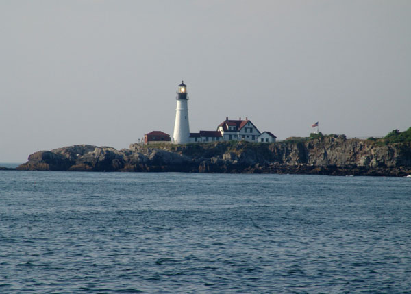 As
we head out between Portland Head Lighthouse and Ram Island Light on our port
side, the seas suddenly get mixed. No more protected calm waters of the
Portland Harbor. The 4 foot swells are definitely out here today and
they are close together making for a bit of rocking and rolling as they are
coming at us right on our beam.
As
we head out between Portland Head Lighthouse and Ram Island Light on our port
side, the seas suddenly get mixed. No more protected calm waters of the
Portland Harbor. The 4 foot swells are definitely out here today and
they are close together making for a bit of rocking and rolling as they are
coming at us right on our beam. 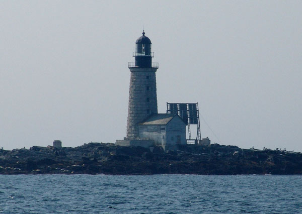 LONELY
OUT HERE
LONELY
OUT HERE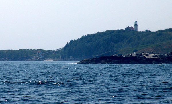 “PLACE
WHERE THE SEA VOMITS”
“PLACE
WHERE THE SEA VOMITS”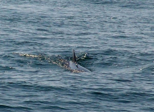 THAR’
SHE BLOWS!
THAR’
SHE BLOWS!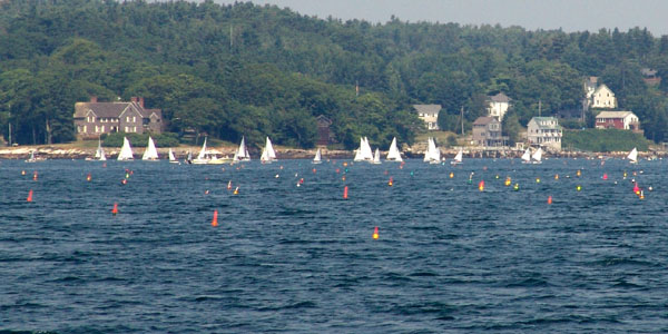 BOOTH
BAY
BOOTH
BAY