Belize
 GLOVER’S REEF, BELIZE GLOVER’S REEF, BELIZE
We left Roatan, wounded and frustrated, but were determined
now to head to Belize and hopefully more civilization. We were definitely
disappointed that we missed out on the Rio Dulce, in Guatamala. Having lost
several days in Roatan due to severe weather, we could not afford the time now.
We had a paid crew member on board and he needed to get back, plus the expense
of it was wearing on us a little. We were sick of the Trade Winds. They were
battering us non stop since we popped out of the Panama Canal.
We traveled all day in rough seas but nothing to complain
about. Our goal was to reach the lowest end of Belize’s 180 mile long barrier
reef. Our destination was Glover’s Reef. You won’t find it in most tour
books. It’s an oval shaped atoll surrounded by what I’ve read is an incredible
wall of living coral. This wall is said to start at 30 feet deep and drops to
more than 2000 feet. It’s a haven for divers.
We slowly and carefully approached the southern opening
very late in the day. It was the first time that we would have to navigate by
what’s under the water and not visible. I guess this is they way you
have to maneuver around these reefs. It was very confusing at first. All we
had to navigate the entrance was a hand drawn sketch that clearly drew the reef,
but the reef was under water and clearly non visible. There were no way points
to go by and the electronic chart was not clear enough. I couldn’t help but
notice the notes on the sketch, twice written by hand, once at the top, and once
at the bottom: “Need Good Light!” and “Enter with Good Light”. We were late in
the day and didn’t have good light! It was overcast and the irritating winds
were howling and creating a ruckus as usual. There were many coral heads noted
on the sketch, but again we couldn’t see any of them. What we did see was an
island, a ¼ mile in length, spotted with palm trees. This was misleading
because there was so much more to the area but it was all underwater. Jim,
having a lot of experience navigating through reefs took the boat in. (He
worked many years as a Captain for the Smithsonian Institute taking scientists
and researchers to many uncharted areas in Panama.)
 I still don’t understand how he brought us in through the
invisible cut, something with “following the parallel navigation lines”? I
don’t know, maybe it was double talk, but we got safely in. It was like
maneuvering through an invisible obstacle. We anchored safely and got the
dinghy down immediately to visit the small island before dusk set. I still don’t understand how he brought us in through the
invisible cut, something with “following the parallel navigation lines”? I
don’t know, maybe it was double talk, but we got safely in. It was like
maneuvering through an invisible obstacle. We anchored safely and got the
dinghy down immediately to visit the small island before dusk set.
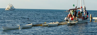
There was a very small dock projecting out from the island
and tied up to it was an unusual fishing boat. There were probably 6 or 7 small
wooden dinghies tied in a line to it’s stern. The boat was packed with dark
skinned fishermen. There really wasn’t enough room for all of them as some were
hanging off the side. They probably spend the day in those small dinghies
pulling nets around together and at the end of the day, they gather together on
the boat, eating and talking.
 As we approached the dock, we were greeted by two large
black dogs. I quickly whisked Ziggy up on my shoulder. They were very
frightening as they kept circling Ziggy and I and barking. The more they
barked the more wound up Ziggy got and feeling very safe up on my shoulder, he
started barking and snarling, showing his teeth. We couldn’t get them to leave
until finally a woman from the fishing boat came and got the dogs like it was no
big deal. As we approached the dock, we were greeted by two large
black dogs. I quickly whisked Ziggy up on my shoulder. They were very
frightening as they kept circling Ziggy and I and barking. The more they
barked the more wound up Ziggy got and feeling very safe up on my shoulder, he
started barking and snarling, showing his teeth. We couldn’t get them to leave
until finally a woman from the fishing boat came and got the dogs like it was no
big deal.
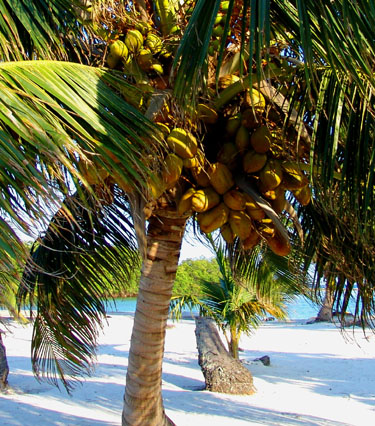
We walked around the mini oasis of an island. We had read
that in recent years a couple had built a resort here. It was described as an
upscale dive resort. I guess for divers this must be upscale but it looked
pretty rustic to me. Maybe because it was abandoned. There were no luxuries
around here. It was closed up like it had gone out of business. We had the
place to ourselves and could walk freely admiring the white sand and palm
trees. There was a “light house” that was supposed to be manned but it looked
abandoned also, unless that woman with the dogs was the light house keeper?
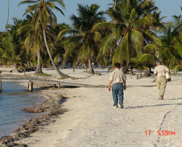
We wondered about the other small island next door
separated by a small stretch of water that could only be traversed by small
boat. We went back to our dinghy and motored to the other island. It was
bigger, but not much bigger. We saw two dive “resorts” or a more accurate
description would be “camps”. One camp had probably 5 huts on stilts which were
totally self contained offering no luxuries. In other words, they had no
electricity, running water or plumbing, and obviously there were no restaurants
or stores nearby. This camp must have been the upscale one as the other
“resort” had no buildings but just tents. I guess this is the epidemy of
the “eco lodge”.

These people were serious
divers who didn’t mind roughing it for the pleasure of the diving experience.
There would be no restaurant for us tonight.
I cooked a quick meal back at the boat and we all went to
bed tired. The wind was blowing strongly outside, and the boat was twirling
around and around. We knew we did not have an easy day ahead of us tomorrow.
 The only comfort on this blustery night was knowing we had three other boats at
anchor near us and we were all doing the anchor ballet together. At times, in
the night, I would awake and look out. I would be checking our holding and
would think I was seeing a boat passing us by. I realized that it was just a
neighboring anchored boat turning in the wind. It gave an optical illusion of a
boat traveling by. I then was comforted seeing through my binoculars, a lantern
lit in one of the other boats, as someone else was awake, reading late into
night and checking their anchor also. The only comfort on this blustery night was knowing we had three other boats at
anchor near us and we were all doing the anchor ballet together. At times, in
the night, I would awake and look out. I would be checking our holding and
would think I was seeing a boat passing us by. I realized that it was just a
neighboring anchored boat turning in the wind. It gave an optical illusion of a
boat traveling by. I then was comforted seeing through my binoculars, a lantern
lit in one of the other boats, as someone else was awake, reading late into
night and checking their anchor also.
We were determined to get to Ambergris Caye tomorrow no
matter how bad the wind and seas were. We didn’t want to get stuck here for
days waiting out the weather. That would not be an option.
HEADING TO AMBERGRIS CAYE
 As morning edged it’s way up over the horizon, we carefully
and slowing edged our way out of the cay maneuvering around those hidden
obstructions, into the safety of deeper water. Again Jim was at this wheel
spouting his method of parallel navigation, which he claimed was the best way to
navigate in the reefs. I still didn’t understand a word of it but he got us out
with no problems so what do I know? The winds had really picked up from last
evening and it wasn’t fun or comfortable. As we got farther and farther north,
the seas got worse and the winds matched their ferocity. As morning edged it’s way up over the horizon, we carefully
and slowing edged our way out of the cay maneuvering around those hidden
obstructions, into the safety of deeper water. Again Jim was at this wheel
spouting his method of parallel navigation, which he claimed was the best way to
navigate in the reefs. I still didn’t understand a word of it but he got us out
with no problems so what do I know? The winds had really picked up from last
evening and it wasn’t fun or comfortable. As we got farther and farther north,
the seas got worse and the winds matched their ferocity.
We headed towards the West side of Turneffe Islands and got
some temporary relief from the Easterly driven Trade Winds. Jim made a joke
about the Turneffe Islands being called “Turn if you Can Islands”. It broke up
the rough ride a little to laugh.
We were studying the entrance to Ambergris Cay on our
chart, or rather another hand drawn sketch. It looked very tricky and in these
rough seas it seemed very risky. We were all getting anxious. Jim would say to
me we had “an 80 percent chance of getting through the reef safely”. I wasn’t
sure if he was kidding or was serious. It certainly didn’t help calm my nerves,
nor did I think it was funny. There was one narrow break in the reef that
provided the only entrance. The seas were so bad that they were breaking over
the reef that was just below the surface. It normally would be easy to spot the
opening but the seas were so high and choppy that it would impossible to see it
until we were on top of it. Once we would get in the opening we would have to
keep the boat straight and then quickly, spot the yellow buoy marking the
dangerous reef in the center of the entrance and then turn to our starboard
immediately to miss it. Once past that reef (again, not visible), we would have
to turn to our port and maneuver our way carefully and slowly in shallow choppy
waters to the marina. We were questioning whether it was going to be safe to
even attempt it.
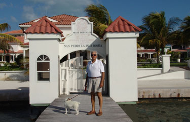
 We called the Belize Yacht Club to see how the seas were
there. We still had the option of trying to go to Belize City to get out of
this and not proceed forward. It would not be an easy entrance there either and
then we didn’t want to get stuck in Belize City either waiting out the weather.
We had heard it was not to be a nice place. Some boaters flatly described it as
a “dump”. We hailed Belize Yacht Club on the radio and they were breaking up
badly but they said they were expecting us. Larry asked how the entrance was
and we were told the yellow buoy that marked the second reef in the entrance was
not there anymore. This made the idea of getting into the reef even more
dangerous. Larry asked if there was a pilot that we could get to come outside
the reef and guide us through. They said “yes”, but he would charge $100.
Larry merely said to “have him ready.” It seemed expensive for a couple minutes
work but we had no choice and the seas were so rough we wondered how a small
skiff would be able to manage. We called the Belize Yacht Club to see how the seas were
there. We still had the option of trying to go to Belize City to get out of
this and not proceed forward. It would not be an easy entrance there either and
then we didn’t want to get stuck in Belize City either waiting out the weather.
We had heard it was not to be a nice place. Some boaters flatly described it as
a “dump”. We hailed Belize Yacht Club on the radio and they were breaking up
badly but they said they were expecting us. Larry asked how the entrance was
and we were told the yellow buoy that marked the second reef in the entrance was
not there anymore. This made the idea of getting into the reef even more
dangerous. Larry asked if there was a pilot that we could get to come outside
the reef and guide us through. They said “yes”, but he would charge $100.
Larry merely said to “have him ready.” It seemed expensive for a couple minutes
work but we had no choice and the seas were so rough we wondered how a small
skiff would be able to manage.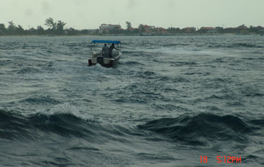
Jim seemed anxious and kept repeating it’s going to be
“hairy”. I was getting anxious just listening to him. I know he’s seen
terrible seas and I’m not sure if he was just teasing me or really was anxious.
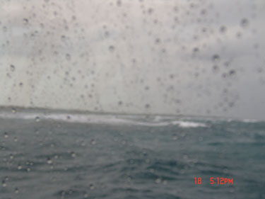
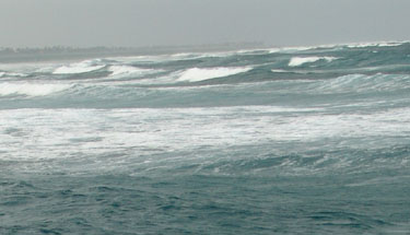
The seas were the roughest we had seen yet, the waves and swells were huge. We
hadn’t seen any other boats out, so were we the only idiots out here? As we
passed Turneffe we saw several boats anchored in the protection of it’s reef. We
could’ve gone there but the entrance would be difficult in this weather also and
as none of us are divers, we didn’t want to get stuck at another place like
Glover’s or Roatan for who knows how long. The weather reports didn’t indicate
any let up in the condition for days so it was Ambergris or keep going. I kept
asking Jim what did he think about going in and he would respond with that same
“we probably have an 80% chance of getting in” thing. To this day, I still
don’t know whether he was kidding or serious.
 I just braced myself in the wheel house settee holding
Ziggy and fearing for the worst. I waited nervously for two long hours before
we reached the entrance to Ambergris. As we approached, I read the cruising
guide: It said “the cut is difficult because of a large drying reef, standing
in the middle of the pass, it forces a dog-leg turn to the north once inside
the cut (this is where the yellow buoy was supposed to be to mark it but now was
not there) . “ It said, “DO NOT attempt this pass in raging sea conditions.
Enter ONLY in good light.” We were entering (1) in raging sea conditions,
(2) bad light, (3) entering without the buoy to mark the second reef, & (4)
guided by a hand drawn chart. Well, that did not make me feel any better. I just braced myself in the wheel house settee holding
Ziggy and fearing for the worst. I waited nervously for two long hours before
we reached the entrance to Ambergris. As we approached, I read the cruising
guide: It said “the cut is difficult because of a large drying reef, standing
in the middle of the pass, it forces a dog-leg turn to the north once inside
the cut (this is where the yellow buoy was supposed to be to mark it but now was
not there) . “ It said, “DO NOT attempt this pass in raging sea conditions.
Enter ONLY in good light.” We were entering (1) in raging sea conditions,
(2) bad light, (3) entering without the buoy to mark the second reef, & (4)
guided by a hand drawn chart. Well, that did not make me feel any better.
 We could see the reef and the huge waves were crashing over
them. The boat was hard to control as it was being pushed in different
directions by the waves. We couldn’t see the break in the reef but knew we were
there by our charts. We called Belize Yacht Club and told them to send the
pilot out. I just couldn’t imagine someone in a small skiff, in these
conditions, being able to meet us out far enough to safely take us in. To my
amazement, in the next moment, two guys on a skiff sped out. They were holding
on to whatever they could as their boat looked like a toy being bopped around
every which way. They rode the waves up and down and to me they were my
heroes. As they got out past the reef, they anxiously waited for us to get
there close enough to follow them. They anxiously waved their arms to come
quickly. We got within 100 yards of them and began our entry trying to follow
this spec of a small boat between two rocky reefs in these raging seas. Our
boat held firm and handled the situation stoically as it followed them in. I
took photos of the exposed reefs on either side and was amazed that behind those
pounding waves, it was like a graveyard of rocks and objects projecting out of
the hidden reef waiting to capture another. I never did see the reef that we
had to dog leg around it was sneakily submerged like so many others we’ve seen
on this trip. We could see the reef and the huge waves were crashing over
them. The boat was hard to control as it was being pushed in different
directions by the waves. We couldn’t see the break in the reef but knew we were
there by our charts. We called Belize Yacht Club and told them to send the
pilot out. I just couldn’t imagine someone in a small skiff, in these
conditions, being able to meet us out far enough to safely take us in. To my
amazement, in the next moment, two guys on a skiff sped out. They were holding
on to whatever they could as their boat looked like a toy being bopped around
every which way. They rode the waves up and down and to me they were my
heroes. As they got out past the reef, they anxiously waited for us to get
there close enough to follow them. They anxiously waved their arms to come
quickly. We got within 100 yards of them and began our entry trying to follow
this spec of a small boat between two rocky reefs in these raging seas. Our
boat held firm and handled the situation stoically as it followed them in. I
took photos of the exposed reefs on either side and was amazed that behind those
pounding waves, it was like a graveyard of rocks and objects projecting out of
the hidden reef waiting to capture another. I never did see the reef that we
had to dog leg around it was sneakily submerged like so many others we’ve seen
on this trip.
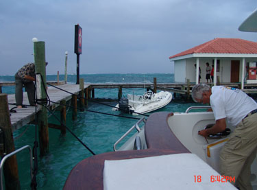

Even though we were finally safely inside the protection of
the dangerous reef, the waters were still very choppy. The pilot boat slowly
and carefully lead us over the shallow waters to the Belize Yacht Club dock
(singular). I glanced at our depth sounder and we had less than a foot under us
all the way to the docks.
The winds were strong even at the dock as Jim backed the
boat in safely to dock. The wind was blowing so strong that I got out every
line we had to hold her. The boat looked like spider man tied her. We had
lines going in all directions and lines over lines trying to keep her in place
between the wobbly poles that we had to secure the boat on. I was surprised how
many people came out on the dock to help us. I guess it must have been a
spectacle watching us come in. Our adrenalin was at its max. I could almost
have kissed the dock I was so happy to get there.
CLEARING
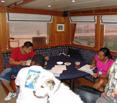 The clearing and customs agents were on board immediately.
We didn’t have time to put away that things that jostled about on the trip. The
agents were black and spoke English. One of the agents was a young woman and
she brushed off the salon table as if it was too dirty for her before she put
her papers on it. I barely had time to get them the usual (cokes & nuts) before
we were hit with a $200 penalty for Ziggy. Apparently, Belize requires a permit
for animals to be obtained prior to arrival. It was another $100 for clearing
and another $80 for who knows what. This didn’t include the $100 for the
pilot. The young woman returned $40 back from the $80 saying it was $80 Belize
dollars which we realized was double American dollars. In our minds we started
to question the other fees whether they were Belize or American. We kind of
figured that they had a nice way to double their money with these not so savy
Americans. My advice to future boaters is to make sure you clarify whether it’s
American dollars or the local. We had become so accustomed to using American
dollars since we hit Panama that we just assumed it was the same. The clearing and customs agents were on board immediately.
We didn’t have time to put away that things that jostled about on the trip. The
agents were black and spoke English. One of the agents was a young woman and
she brushed off the salon table as if it was too dirty for her before she put
her papers on it. I barely had time to get them the usual (cokes & nuts) before
we were hit with a $200 penalty for Ziggy. Apparently, Belize requires a permit
for animals to be obtained prior to arrival. It was another $100 for clearing
and another $80 for who knows what. This didn’t include the $100 for the
pilot. The young woman returned $40 back from the $80 saying it was $80 Belize
dollars which we realized was double American dollars. In our minds we started
to question the other fees whether they were Belize or American. We kind of
figured that they had a nice way to double their money with these not so savy
Americans. My advice to future boaters is to make sure you clarify whether it’s
American dollars or the local. We had become so accustomed to using American
dollars since we hit Panama that we just assumed it was the same.
It had not been necessary to change money from Panama as
the American dollar was used throughout Panama, Columbia and Honduras. Also, as
a side note, we had to pay for almost everything since Panama with cash! Credit
cards were rarely accepted. It’s a good thing we had a lot of cash on board
though it made us nervous us nervous having that much aboard. (It was a good
thing we had Tom Scarvie bring us an $3000 cash in Costa Rica.)
Well, we were really glad to be here and didn’t mind if we
had to stay for a few days. Ambergris looked like fun. It had a little town
called San Pedro and was filled with restaurants, shops and lots of charm so we
snuggled in and decided to enjoy it until mother nature settled down.
There are a gazillion cafes in San Pedro, so we ate out
a lot. We also ate out a lot because it was difficult to find fresh fruits and
vegetables, and the meats didn’t look very fresh or appetizing. So, it was
easier and more fun to eat out for awhile.
NOW on to SAN PEDRO, AMBERGRIS, BELIZE
|