|
|
|
CHARLESTON TO GEORGETOWN, SOUTH CAROLINA
One thing it didn’t mention was keeping track
of your position on these long straight stretches. They are so straight and
with no land marks that before you know it, you lose track of your location. The
navigation lines are all set on a diagonal and when trying to catch up and plot
with the GPS it is still a little confusing. To keep this from happening, I
just got in the habit of crossing off landmarks as we went on the chart and also
marking the time we passed each one. This way I could keep track and anticipate
any problem areas ahead. Of course, Larry always knew where we were on the
electronic chart but I always like to track it on paper.
We left with Ocean Bear about 8:00 AM and
crossed the inlet to Charleston and made the tricky dog leg turn into the ICW at
Sullivan Island and started up the first narrow straight shot. I had read the
cruising guide the night before and got into the habit of highlighting problem
areas on the paper chart so we would be prepared when we got there.
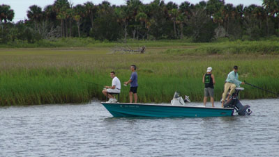
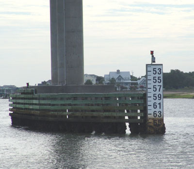
We saw locals out fishing off the side of the river in their flat skiffs. Docks and decks extending into the river are a big thing here. We pass several and people treat them like they are their back porches. We pass under our first bridge and see by the marker that we have 67 feet clearance as the tide is down a foot and a half. We only need 34 feet. Our 34 feet gets us under most but we’re not short enough to do the Big Circle Loop up through the Great Lakes and down.
We reach mile 450 where the current changes
direction. Everything is referenced on the chart by mile markers as mile zero
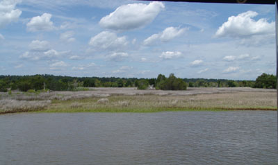
for the ICW starts at Norfolk and ends in Key West. It’s beautiful
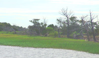
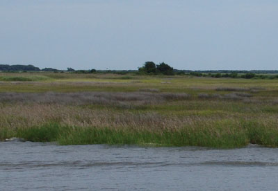
countryside. The marshlands go on forever and occasionally now we see some old
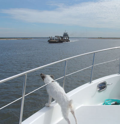
abandoned shack of a day gone by. Once we pass a barge but the day is really
just Ocean Bear and us. We call each other on the radio every so often to
check in or break up the day or comment on the beautiful landscape. We both are
commenting on the uniqueness of what we are seeing and how lucky we are to be
doing this.
LET’S GO SHRIMPIN’
Around noon time we are nearing Mc Clellanville.
I remember this name only because the jet skiers and other boaters back in
Beaufort had warned us about the shallow depths here and said this would be
where we would have a problem if we would have one. There are no warnings in
the cruising guide so we are only listening to local info now. Jeremy Creek
which is too shallow for us, takes off to the left to Mc Clellanville, which is
supposed to be an old fishing village dating back to the 1700’s. The Creek is
said to be 4.9 feet deep which is too shallow for us. The guide says this is
the home port of many of the shrimp boats in this area. I would’ve loved to
have seen this village as it is very remote by car and even by boat and dating
back to the 1700’s it must be very unique.
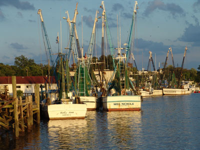
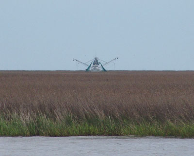
Shrimp is big here in Georgia and the
Carolina’s. It really is Bubba Gump country. The white shrimp boats
are a site with their rusty sides and big brown nets draping over the sides, but
their names painted on the sides are skillfully, artfully, and pride fully done.
Just to see these boats makes you hungry for shrimp.
We pass Five Fathom Creek which empties into the ICW right at Mc Clellanville. This Creek is the inlet to the Atlantic and is said to be well marked for the shrimp boats. We watched one shrimp boat that looked like it was stuck in the marshes but he was moving like we were, it was just that he was in Five Fathom Creek which for part of its leg is parallel to us. It was an amazing site. We watched him for a good part of the day as he would sometimes be facing in our direction and then sideways as we both meandered through the marshes but on different paths.
CONTINUING ON THROUGH THE MARSHLANDS
Throughout the day was passed what we thought used to be old plantation rice fields with ancient wooden irrigation dams. They were leftover from the old rice plantations, miles and miles of it. It was peaceful and beautiful, these expansive landscapes with blue skies and puffy white clouds overhead.
The docks at Georgetown were old and rickety.
GEORGETOWN, South Carolina
They did so well with what they call the “Carolina Gold”, which is a local variety of rice that they exported more rice from here than any other port in the world. The profits from this venture, it is said, developed a “genteel society” which is seen by the neighboring plantations and some of the grand homes on Georgetown waterfront.
A LITTLE UNFRIENDLY
It’s a small town from what we could explore from walking along the river front. It’s anchored by a huge steel mill that you can see bellowing with a glow during the night and the puffs blow into the sky. The town is built along the river edge and just down from us was an “independent fish market/supplier” with old bowed wooden docks with wonderful shrimp boats tied to the old piers.
Our “marina” was rustic and old and barely big enough for us and though Larry kept telling the “dock master” that he didn’t think there was going to be enough water under us when the tide went out, the dock master’s only answer was “no problem”. After he went home for the night, Larry was still unconvinced so Larry, Steve, Joann and I ended up pulling the boat out further from the shore line and let Knotty Dog hang out in the channel to gain her more depth underneath the bow area. This gave Larry about a foot now underneath that Larry worried about the whole night. He finally subsided and said, well if it sets on bottom it’ll be on the mud so it’ll be OK. We got there late in the day so we all went to town to see what the place was like.
We stopped at the local bakery that we had read about in one of the East Coast boater’s rags saying it was the best bakery on the Atlantic Coast. We bought some bread and wine and a few of their local deli items like fresh homemade raviolis. The clerks were not friendly at all and I guess it was too close to closing time as they seemed not anxious to wait on us. The one clerk waiting on Joann didn’t pack her items probably and it was obvious that the bag would rip before we could get it back to the boat. Joann asked for another bag to at least double bag it and the clerk pointed her off to their other store that handled kitchen gadgets. She said she didn’t have any more bags and that she could try to get one there. She didn’t offer to carry the items to the next store to properly package it nor did the next clerk seem too anxious to help. Joann and I both were beginning to think the people in the town were a little strange and unfriendly.
We put in early as we had another long day ahead of us tomorrow. As we were studying the charts and guide books for tomorrow we couldn’t help but notice a couple tour boats coming in well after dark. They were loaded with people that had been out sightseeing. The only destination that we could think of that would bring them in so late may have been a journey up the Waccamaw River to do a plantation tour. The cruising guide said there are several of these tour boats in this area and that they have quite a business doing plantation tours, island tours, and wilderness tours. The guide book said “some do not look seaworthy, especially the river boats. A wake might swamp the likes of these craft. Even vessels with minimum wake should give these tour boats a slow pass.” They did look over crowded and we were surprised as they came in well past dark. They would be hard to see.
|
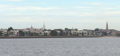
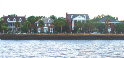 As we left Charleston, we passed the waterfront
and the view of colonial homes and church spires was quite a site. Ocean Bear
was leading the way this time so we would be able to relax a bit as the one who
goes first is the one who rubs the mug first. We passed old Fort Sumpter on our
right. It’s the old sentinel that has guarded the city since the early days.
As we left Charleston, we passed the waterfront
and the view of colonial homes and church spires was quite a site. Ocean Bear
was leading the way this time so we would be able to relax a bit as the one who
goes first is the one who rubs the mug first. We passed old Fort Sumpter on our
right. It’s the old sentinel that has guarded the city since the early days.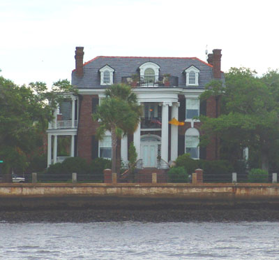 We are about to enter some of the straightest
sections of the ICW on our whole trip and it is said to be some of the
prettiest. The guide book recommended two things: (1) “Slow boats need to pay
more attention than fast ones” as there are many streams and rivers that may
affect the tidal current flow creating side currents. And (2) “The charted
depths are somewhat optimistic along this stretch, so be more precise in keeping
to the channel at low tide.”
We are about to enter some of the straightest
sections of the ICW on our whole trip and it is said to be some of the
prettiest. The guide book recommended two things: (1) “Slow boats need to pay
more attention than fast ones” as there are many streams and rivers that may
affect the tidal current flow creating side currents. And (2) “The charted
depths are somewhat optimistic along this stretch, so be more precise in keeping
to the channel at low tide.”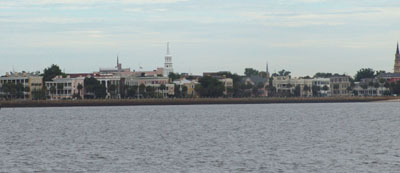
 Sullivan
Island was one big high lighted circle for shoaling problems but we had no
difficulty. It was again a pretty area with lovely marsh lands and was slightly
settled with houses. We were again delving into a beautiful landscape that not
too many people see as they don’t have the opportunity to travel up this ICW.
Sullivan
Island was one big high lighted circle for shoaling problems but we had no
difficulty. It was again a pretty area with lovely marsh lands and was slightly
settled with houses. We were again delving into a beautiful landscape that not
too many people see as they don’t have the opportunity to travel up this ICW.
 We pass Isle of Palms which is heavily settled
with golf courses and resorts. We see our first golfers on the shore as we pass
by. Nearby is Goat Island which has a few vacation cottages. It used to be
owned by the “Goat Man”. From the early 30’s to the 60’s, the Goat Man and his
family were the only inhabitants, and they lived as hermits, raising goats and
eating and surviving off the land. Nothing is left but the legend now. We
didn’t see any wild goats roaming.
We pass Isle of Palms which is heavily settled
with golf courses and resorts. We see our first golfers on the shore as we pass
by. Nearby is Goat Island which has a few vacation cottages. It used to be
owned by the “Goat Man”. From the early 30’s to the 60’s, the Goat Man and his
family were the only inhabitants, and they lived as hermits, raising goats and
eating and surviving off the land. Nothing is left but the legend now. We
didn’t see any wild goats roaming.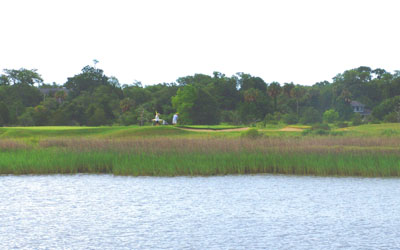
 They
love their shrimp here. It’s true what Bubba said to Forrest Gump, “You
can barbecue it, boil it, broil it, bake it, sauté it. There’s shrimp
kabobs, shrimp Creole, shrimp gumbo….pan-fried, deep-fried, stir-fried….shrimp
salad, shrimp burger, shrimp sandwich….” Shrimp is the back bone of
Low country Cooking.
They
love their shrimp here. It’s true what Bubba said to Forrest Gump, “You
can barbecue it, boil it, broil it, bake it, sauté it. There’s shrimp
kabobs, shrimp Creole, shrimp gumbo….pan-fried, deep-fried, stir-fried….shrimp
salad, shrimp burger, shrimp sandwich….” Shrimp is the back bone of
Low country Cooking. We passed the 417 mile mark and passed names on
our chart like, Little Duck Creek, Crow Island, and Cat Island. Even the guide
becomes charming and caring saying things like; “Shoals and strong currents are
prevalent, so take extra care.” If was like the guide was watching out for us
and whomever passed this way. We had no problems this whole day as depths were
fine and we got the rhythm of the river down. We passed more oyster shell
mounds and they became somewhat a common place site now along with the osprey
nests.
We passed the 417 mile mark and passed names on
our chart like, Little Duck Creek, Crow Island, and Cat Island. Even the guide
becomes charming and caring saying things like; “Shoals and strong currents are
prevalent, so take extra care.” If was like the guide was watching out for us
and whomever passed this way. We had no problems this whole day as depths were
fine and we got the rhythm of the river down. We passed more oyster shell
mounds and they became somewhat a common place site now along with the osprey
nests.
 We new we were getting close to civilization
when we came upon a tug pulling another smaller tug by its side. Ocean Bear
hailed it several times to ask for a passing but no answer. It was an old rusty
thing and scroungey guys on the back who just ignored them. They could clearly
see them but would not give them the time of day. After a few tries Ocean Bear
managed to get by them at a wider section of the ICW. Then it was our
turn. We too tried to hail them on the radio but no answer.
We new we were getting close to civilization
when we came upon a tug pulling another smaller tug by its side. Ocean Bear
hailed it several times to ask for a passing but no answer. It was an old rusty
thing and scroungey guys on the back who just ignored them. They could clearly
see them but would not give them the time of day. After a few tries Ocean Bear
managed to get by them at a wider section of the ICW. Then it was our
turn. We too tried to hail them on the radio but no answer. 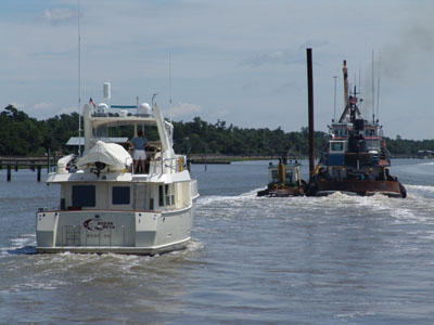 Larry
finally gave them one shot blast and tried to pass on our port side. They
didn’t answer the horn signal either. It seemed like they actually sped up
when we tried to get by and it made the passing scary and difficult. They
just ignored us as we struggled to get by. I guess they don’t like
recreational boaters around here.
Larry
finally gave them one shot blast and tried to pass on our port side. They
didn’t answer the horn signal either. It seemed like they actually sped up
when we tried to get by and it made the passing scary and difficult. They
just ignored us as we struggled to get by. I guess they don’t like
recreational boaters around here.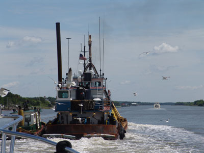 We had another unfriendly incident when we past
a small little ferry station on the north side of Cat Island. There were no “NO
WAKE” signs only a sign saying “FERRY CROSSING AHEAD”. A huge fast power boat
had sped by us a few minutes earlier creating a terrible wake for us and did the
same at the ferry crossing. Our Nordhavns don’t create much wake even when
we are going our maximum. We weren’t doing our max and I guess when we
came by the after effects of the speed boat ahead of us, it was more than the
locals could tolerate.
We had another unfriendly incident when we past
a small little ferry station on the north side of Cat Island. There were no “NO
WAKE” signs only a sign saying “FERRY CROSSING AHEAD”. A huge fast power boat
had sped by us a few minutes earlier creating a terrible wake for us and did the
same at the ferry crossing. Our Nordhavns don’t create much wake even when
we are going our maximum. We weren’t doing our max and I guess when we
came by the after effects of the speed boat ahead of us, it was more than the
locals could tolerate.
 As we passed behind Ocean Bear we could see a man running down the dock and
hopping into a small speed boat that said “Constable” on the side. He
raced past us yelling something and caught up to Ocean Bear and gave them a
piece of his mind. That wasn’t enough for him as he came back and yelled
at us. I couldn’t get a word in edgewise except to say we were sorry but
that didn’t seem to calm him. He sped off in a huff. I imagine it is
intolerable for them as many of these power boats don’t give a damn about the
wakes they leave behind and the damage they do. I think he just decided to
take his frustrations out on us. It worked because it made all of us feel
terrible.
As we passed behind Ocean Bear we could see a man running down the dock and
hopping into a small speed boat that said “Constable” on the side. He
raced past us yelling something and caught up to Ocean Bear and gave them a
piece of his mind. That wasn’t enough for him as he came back and yelled
at us. I couldn’t get a word in edgewise except to say we were sorry but
that didn’t seem to calm him. He sped off in a huff. I imagine it is
intolerable for them as many of these power boats don’t give a damn about the
wakes they leave behind and the damage they do. I think he just decided to
take his frustrations out on us. It worked because it made all of us feel
terrible.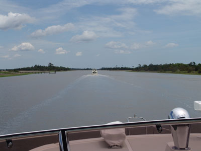 As we exited the Estherville Minim Creek Canal,
where the ferry incident occurred, and entered Winyah Bay nearing our Georgetown
our destination that day, we heard several boaters calling in to the coast guard
to notify them that several large pilings had come lose and were floating near
the entrance to Sampit River at Georgetown just off Rabbit Island and Hare
Island.
As we exited the Estherville Minim Creek Canal,
where the ferry incident occurred, and entered Winyah Bay nearing our Georgetown
our destination that day, we heard several boaters calling in to the coast guard
to notify them that several large pilings had come lose and were floating near
the entrance to Sampit River at Georgetown just off Rabbit Island and Hare
Island.
 They were reported very dangerous and hard to see as they were mostly submerged.
As I say on this trip, over and over, it’s always a test. Thanks
to good boaters that reported the positions we were aware of the situation and
entered with caution until we were able to spot the submerged pilings and then
carefully entered the River to Georgetown.
They were reported very dangerous and hard to see as they were mostly submerged.
As I say on this trip, over and over, it’s always a test. Thanks
to good boaters that reported the positions we were aware of the situation and
entered with caution until we were able to spot the submerged pilings and then
carefully entered the River to Georgetown.
 We barely had enough room on the dock for us and really not enough water beneath
us. Ocean Bear had a tricky location to get into also but Joann took it slow
and got it in. The docks are fixed and not floating and are always difficult to
get the boat tied up to. You have to wrestle with the poles trying to lasso the
lines around them and at the same time try to keep the boat away from the wooden
pilings that stick out until you can move all the fenders around to give you
protection.
We barely had enough room on the dock for us and really not enough water beneath
us. Ocean Bear had a tricky location to get into also but Joann took it slow
and got it in. The docks are fixed and not floating and are always difficult to
get the boat tied up to. You have to wrestle with the poles trying to lasso the
lines around them and at the same time try to keep the boat away from the wooden
pilings that stick out until you can move all the fenders around to give you
protection. 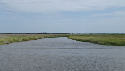 Then getting in and out is a real exercise as sometimes the boat is
high and sometimes it’s low to the dock, depending on the tide. Glad we have
several doors that open on different levels to give us some options.
Then getting in and out is a real exercise as sometimes the boat is
high and sometimes it’s low to the dock, depending on the tide. Glad we have
several doors that open on different levels to give us some options.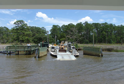
 Georgetown’s history goes way back to the
1700’s. It was a real cultural mix back then. Several different tribes of
American Indians lived alongside a mix of European settlers including the
English, French and Scottish. When the settlers first realized that the low
country was ideal for producing rice and indigo that brought in a whole new
industry, the slave trade. This mix is what formed Georgetown and made it what
it is today. Since Georgetown has an easy access inlet to the ocean it became a
major port in the 1700’s and that’s what put it on the map.
Georgetown’s history goes way back to the
1700’s. It was a real cultural mix back then. Several different tribes of
American Indians lived alongside a mix of European settlers including the
English, French and Scottish. When the settlers first realized that the low
country was ideal for producing rice and indigo that brought in a whole new
industry, the slave trade. This mix is what formed Georgetown and made it what
it is today. Since Georgetown has an easy access inlet to the ocean it became a
major port in the 1700’s and that’s what put it on the map.
 The town was cute and small and old. Several
little tourist shops and café’s lined the main street. We were told the best
place in town to eat was the Rice Pattie so we walked there to
make reservations. The stall wasn’t too friendly when we went in and didn’t
come to wait on us very quickly but we didn’t let that stop us. The town has a
new boardwalk that links several restaurants that overlook the river. You can’t
help but notice the huge steel and pulp mill that seem to have equal importance
to the town buildings. The neighboring blocks have several quaint B&Bs and
lovely homes with tree shaded wide streets.
The town was cute and small and old. Several
little tourist shops and café’s lined the main street. We were told the best
place in town to eat was the Rice Pattie so we walked there to
make reservations. The stall wasn’t too friendly when we went in and didn’t
come to wait on us very quickly but we didn’t let that stop us. The town has a
new boardwalk that links several restaurants that overlook the river. You can’t
help but notice the huge steel and pulp mill that seem to have equal importance
to the town buildings. The neighboring blocks have several quaint B&Bs and
lovely homes with tree shaded wide streets.
 Maybe we caught the town at a bad time but we
certainly left with a strange feeling. We had a nice meal at the Rice Pattie
and I couldn’t help notice the way many of the customers dressed. They love
their pastels colors here, including the men. Pink and lavender shirts are in
and multi colored ribbon belts for the women of the same colors are as popular.
It was the brightest collection of people in one room that I think I’ve ever
seen.
Maybe we caught the town at a bad time but we
certainly left with a strange feeling. We had a nice meal at the Rice Pattie
and I couldn’t help notice the way many of the customers dressed. They love
their pastels colors here, including the men. Pink and lavender shirts are in
and multi colored ribbon belts for the women of the same colors are as popular.
It was the brightest collection of people in one room that I think I’ve ever
seen.